BIG Blood Donation Drive – 10 February 2015

BIG Blood Donation Drive – 10 February 2015

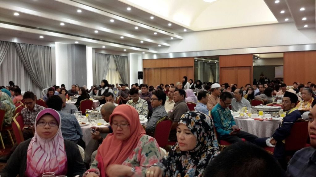
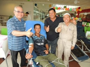
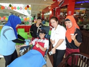
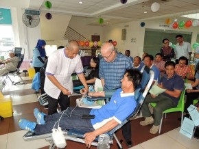
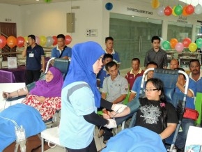
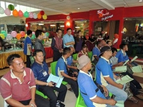
THE Brunei Institution Of Geomatics (BIG) together with the Raja Isteri Pengiran Anak Saleha (RIPAS) Hospital Mobile Blood Bank and its food partner SCR Express on Tuesday held a very successful joint Blood Donation Campaign at the Citis Square outlet.

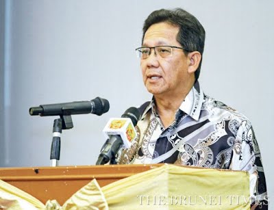
BIG President Pg Hj Matusin Pg Hj Matasan said the campaign was organised as part of the organisers’ corporate social responsibility — to assist RIPAS Hospital to boost its blood reserves.

BIG President, Pg Hj Matusin bin Pg Hj Matasan, and some donors giving the thumbs-up. He appealed to all able-bodied individuals to step forward and make a difference in the community

“As everyone is well aware, Brunei Darussalam’s population is small, and obtaining blood donations is therefore understandably quite a challenge. Further compounding this situation is the fact that an increasing number of people are suffering from chronic diseases (according to recent health reports) and are disqualified from donating,” explained Pg Hj Matusin on why there is always a shortage of blood, judging from the many appeals for blood being circulated in the local social media.

“On behalf of all the needy patients out there, I would like to take this opportunity to thank everyone who has donated blood to assist them…At the same time, I would also like to appeal to all able-bodied individuals to step forward to make a difference in our community. Your country and community need you…And remember, one doesn’t have to be a doctor or a paramedic to save lives — just donate some blood. Besides, it is good for health,” added Pg Hj Matusin.

Article & Photos Courtesy of Brunei Times

http://m.bt.com.bn/happenings/2015/02/12/big-blood-donation-drive

Surveyors Night 2015 – 03 February 2015

BRUNEIAN surveyors need to be equipped with skills and knowledge to continue providing professional services following the enforcement of the Strata Title Act, the Minister of Development said last night.

Minister of Development YB Pehin Dato Hj Suyoi delivers his speech during the Surveyors’ Night


Pehin Orang Kaya Indera Pahlawan Dato Seri Setia Hj Suyoi Hj Osman said a professional surveyor of any discipline such as valuer, quantity surveyor or land surveyor need to undergo continuous professional development to command the trust and respect of the public.

“Such professional integrity and expertise cannot be over-emphasised than the recent developments both in Brunei and ASEAN region as a whole,” he said during the Surveyors’ Night at the Parkview Hotel, Jerudong.

YB Pehin Dato Hj Suyoi said ASEAN member states agreed to establish a single market that will directly impact the mobility of various professionals including surveyors.

“I have been informed that in the meeting of the ASEAN Coordinating Committee on Services, Brunei Darussalam, Malaysia and Singapore have shown significant progress in land surveying. I hope the other two disciplines of valuation and quantity surveying will follow suit.”

The minister added that the Royal Institution of Chartered Surveyors (RICS) ASEAN can assist their members in Brunei by disseminating up-to-date information and provide relevant training programmes.

“Strict compliance to these international standards will only ensure the integrity and capability of a professional surveyor to the level expected by any country and hence achieving the ASEAN Free Trade Area,” he said.

The Surveyors’ Night also saw Bill Jones, managing director of RICS ASEAN, giving a talk on ‘The International Standards for the Surveyors’ – covering the three aspects of valuation, measurement and ethics.

Guests Enjoying the Function


Article Courtsey of Brunei Times

http://www.bt.com.bn/news-national/2015/02/04/continue-updatingskills-surveyors-told

UTAP Seminar 2014 – 28 August 2014

UTAP Seminar 2014 – 28 August 2014

‘UKUR TANAH ASAS PEMBANGUNAN (UTAP)’ SEMINAR 2014 

28 August 2014, Wednesday, Bandar Seri Begawan – The ‘Ukur Tanah Asas Pembangunan (UTAP)’ Seminar 2014 was jointly organized by the Survey Department, Ministry of Development and the Brunei Institute of Geomatic (BIG). The seminar was held on Thursday, 2 Zulkaedah 2014 corresponding with 28 August 2014 at the Rizqun International Hotel, Gadong. Present as the guest of honour was Yang Mulia Dato Paduka Haji Suhaimi bin Haji Gafar, Permanent Secretary (Technical and Professional) Ministry of Development, Brunei Darussalam.


Guest of Honour, Dato Paduka Haji Suhaimi bin Haji Gafar delivering his speech

The ceremony began with the welcoming address by Yang Mulia Awang Haji Ali Bakar bin Haji Kasim, Acting Surveyor General, the chairperson of the event. A speech was then delivered by the guest of honour and subsequently officiated the seminar.

Acting Surveyor General, Haji Ali Bakar bin Haji Kasim, delivering his speech


Five working papers were presented by speakers from the educational institute UBD-IBM and invited speakers from Sabah and Singapore as well as from the private sector.

The speakers and the title of their papers were as follows

  • Soh Keng Peng of Singapore Land Authority “3D Cadastre – How to Deal with Space”
  • Dr Teng Chee Hua of Department of Surveying & Mapping Malaysia “Developments of 3D Cadastre in Malaysia”
  • Hj Safar b Untong of Lands and Survey Department Sabah, Malaysia “Development of Multi-Purpose Cadastre in Sabah”
  • Dr. Sandhya Aneja of UBD Brunei “GIS Based Flood Mitigation”
  • Joe Wong of Total Monitoring Control Malaysia “Slope Surface Monitoring Using Robotic Total Station”

The papers are available for viewing or downloading below

The aim of the UTAP Seminar is to gather professionals in the land survey and geomatic sector as well as to share knowledge on recent projects carried out by local and regional government and private agencies

The participants of the seminar comprised of officers from various government departments and private companies especially in the field Of Land Surveying, Architecture, Developers, Town and Country Planning, Educational Institutions as well as Licensed Land Surveyors.


Participants at the Seminar
Senior Government Officials & BIG President
Dr. Sandhya Aneja of UBD presenting her paper on GIS Based Flood Mitigation
Dr Teng Chee Hua of Department of Surveying & Mapping Malaysia presenting his paper on Developments of 3D Cadastre in Malaysia
Presenters and Moderator during Q&A Session


The first UTAP Seminar was held in 1985. The seminar is organized every two years and this year’s seminar is held in conjunction with the 30th Joint Surveyors Board Meeting which was held on Wednesday, 1 Zulkaedah 1435 corresponding with 27 August 2014. The theme of this year’s seminar is ‘Cadastre Innovation For Sustainable Development’. It focuses on the progress and the latest technological developments especially in the use and management of land survey.

Press Release & Photos Courtesy of Survey Department

http://survey.gov.bn/web/survey_department/latest-news

The papers presented at the seminar can be viewed or downloaded by clicking on the links below

MoU Between PUJA & BIG – 17 May 2014

MoU Between PUJA & BIG – 17 May 2014

A Memorandum of Understanding (MoU) between Pertubuhan Ukur Jurutera Dan Arkitek [PUJA] (Brunei) and Brunei Institution of Geomatics (BIG) will be signed on 17 May 2014 in conjunction with Surveyors Night 2014. The MoU is as follows:

 
Pertubuhan Ukur Jurutera Dan Arkitek [PUJA] (Brunei) and Brunei Institution of Geomatics (BIG) see benefits to members of both professional parties in establishing a Memorandum of Understanding between the two (2) Institutions and agree the following:-
  1. PUJA (Brunei) and BIG will build and maintain a long term co-operative relationship and encourage the exchange of professional knowledge and development.
  2. PUJA (Brunei) and BIG will collaborate in:                                                                                                        a) Co-branding of Continuous Professional Development (CPD) events and to offer members of PUJA (Brunei) and BIG the same rates for such events.                                                                                          b) Sponsorship of professional events.
  3. Each professional body will notify the other of any proposed merger or major constitutional change.
  4. The leadership of PUJA (Brunei) and BIG will meet at least once in every two (2) years or earlier to discuss matters of common interest.
  5. PUJA (Brunei) and BIG will keep each other informed of major changes that are of interest to the other.
  6. In the event of either of the professional bodies wishing to end this agreement, at least one (1) year’s written notice shall be served to the other party.

Surveyors Night 2014 – 17 May 2014

Surveyors Night 2014 – 17 May 2014

SURVEY professionals, PUJA and all those in construction industry should come up with solutions which are in line with sustainable development, said Minister of Development yesterday (17 May 2014).

Yang Berhormat Pehin Orang Kaya Indera Pahlawan Dato Seri Setia Hj Suyoi Hj Osman was speaking at the Surveyors’ Night organised by the Association of Brunei Surveyors, Engineers and Architects (PUJA) and Brunei Institution of Geomatics (BIG) at Orchid Garden Hotel, Kg Anggerek Desa.

Minister of Development YB Pehin Dato Hj Suyoi giving his speech at the Surveyors’ Night


He urged that such solutions should not cause unnecessary damage to the natural environment like deforestation and using hazardous materials.

“Concern for the environment is no longer something that we just talk about.

“We all play a role to ensure that our current lifestyle, our buildings and homes, and our neighbourhood are environmentally-friendly,” he said.

YB Pehin Dato Hj Suyoi also said: “50 per cent of natural resources used were for construction-related activities, and over 50 per cent national waste productions are also from the construction sector.”

Last night also saw the signing of memorandum of understanding between PUJA (Brunei) and BIG. The signing was witnessed by PUJA President and Legislative Council member Hj Zulkipli Hj Abd Hamid.


Vice President of PUJA (Surveyors Division) Mohd Shafie Hj Mohd Yusof (Left) and
President of BIG Alimin Hj Kalong (Right) after signing the MoU

BIG Council Members Attending the Function


Attendees at the Function


Source: The Brunei Times – 18 May 2014
Survey Department Geoportal Launching – 28 November 2013

Survey Department Geoportal Launching – 28 November 2013

GEOSPATIAL information can now be viewed publicly through a web portal called the GeoPortal which was previously exclusive only to departments under the Ministry of Development (MoD) since its inception in 2012.

A workshop was organised by the Survey Department yesterday at the Institute of Civil Services (IPA) to familiarise some 80 officers from different ministries and departments to their work flows on the web portal so they could apply its usage to their respective professions – and make their work easier.


Attendees at the Geoportal Launching


In a press statement given yesterday, the GeoPortal was designed to allow non-expert public users to enjoy viewing land information in Brunei – the public will have access to 2009 orthophotos and superimposed with selected features for the whole of Brunei.

The system also provides an online search engine using location names, places of interest, geographical coordinates and lot parcels. According to the guest of honour, Hj Muhd Lutfi Abdullah, Permanent Secretary (Administration and Finance) in the Ministry of Development (MoD) during the launching ceremony, the usage of Internet, especially in the context of governmental matters, made the provision of services to the public more convenient – there is no need for a face-to-face interaction.

“In support of this idea, the survey department has prepared a platform called GeoPortal Survey, which allows public access to the spatial data infrastructure,” he said.

“It can be accessed through Internet as part of an effort from the Survey Department to provide spatial information for work matters, which could be beneficial, saving time and energy for the other government agencies, private sectors and the general public,” he added.

“The government will not be hesitant in taking action against those who constructed or developed government lands without permission especially on routes, even without knowing the position and measurements of the land.”

In an interview with The Brunei Times, Isham Ismail an officer from the Islamiah Da’wah Centre, Ministry of Religious Affairs (MoRA) said that the course introduced the GeoPortal as a system similar to Google map with its only difference being specifically for Brunei.

Isham pointed out that at times it is difficult to locate the places where they have to go to as propagators and this is where it comes in handy. On the other hand, a maintenance engineer from the Royal Brunei Police Force (RBPF), Mohd Solehin Hj Masri said that the GeoPortal Survey will be quite useful to his profession.

“The GeoPortal Survey will be quite useful for us to do radio coverage,” he said.

Source: The Brunei Times – 29 November 2013

Property Investment Seminar – 16 May 2013

Property Investment Seminar – 16 May 2013

COOPERATION between relevant parties is key in ensuring the success of the country’s property industry, the President of the Brunei Institution of Geomatics (BIG) said on Thursday (18 May 2013).

In his speech during BIG’s ‘Property Investment Seminar’ at the Indera Pahlawan Hall at the Ministry of Development Training Centre, Alimin Hj Kalong said that with better awareness about the property market, the market players can then help push the industry forward.

President of the Brunei Institution of Geomatics Alimin Hj Kalong
delivering his speech during the seminar


“It is my hope that this seminar will be able to shed some lights into the complexity and dynamics of the property industry so that all those involved can increase their knowledge and awareness and come up with a mutual understanding so that together we can contribute to the growth of this industry, and eventually, the economy of our country,” he said.

He also explained that the industry is “a system of complex economic activities” that is made up of many stakeholders and that any change in one aspect will affect the other.

“Any changes in any of these components, for example, new rules or law has an impact on the real estate industry as a whole,” he said.

He added that the property industry is also a significant contributor to the nation’s economy among the non-oil and gas sector.

The seminar featured presentations by the Bangkok-based independent property consultancy Agency for Real Estate Affairs Co Ltd (AREA) President Dr Sopon Pornchokchai and Robin Cheok from Cheok Advocates & Solicitors.

In his presentation, Pornchokchai said that Brunei should be active investors in property in the “ASEAN peninsula” and have the same drive when promoting the local property market.

“If Brunei wants to promote investment, the country has to take part in property seminars and events to promote their property.”

Further in his presentation, he also explained the various factors and mechanisms that determine the rise and fall of property prices in the neighbouring countries.

Meanwhile, Cheok spoke about the legal landscape of property in the country. He said that since the Ministry of Development has abolished the property ownership through power of attorneys or trust deeds, bankers and law practitioners have been working with the ministry to smoothen the transition process.

He also touched on the need for more awareness on the strata titles among property owners.

“If building owners are aware and convert their existing properties into strata properties, the value of their property would increase,” he said, adding the outcome would also positively affect the real estate market.

In March, Development Minister Yang Berhormat Pehin Orang Kaya Indera Pahlawan Dato Seri Setia Hj Suyoi Hj Osman said that the government is facing challenges in pin-pointing the success of the strata title adding that there is still a lack of interest among property owners in Brunei.

Source: The Brunei Times – 18 May 2013

Global Navigation Satellite System Seminar – 26 March 2013

Global Navigation Satellite System Seminar – 26 March 2013

THE Ministry of Development’s departments and relevant agencies were advised to continue improving the quality and efficiency of their services in line with the advancements in technology.

This is aimed at meeting the requirements of customers faster by simplifying their application process with a skilled and knowledgeable workforce.

Minister of Development Yang Berhormat Pehin Orang Kaya InderaPahlawan Dato Seri Setia Hj Suyoi Hj Osman said this yesterday in expressing his hope of having modern technology used in enhancing quality, productivity and efficiency in carrying out services from the government namely those involved in land development, construction of infrastructure and buildings as well as other public interests.


Development Minister, YB Pehin Dato Hj Suyoi (2nd R), touring the exhibition put up during the
Global Navigation Satellite System Seminar


THE Ministry of Development’s departments and relevant agencies were advised to continue improving the quality and efficiency of their services in line with the advancements in technology.

This is aimed at meeting the requirements of customers faster by simplifying their application process with a skilled and knowledgeable workforce.

Minister of Development Yang Berhormat Pehin Orang Kaya InderaPahlawan Dato Seri Setia Hj Suyoi Hj Osman said this yesterday in expressing his hope of having modern technology used in enhancing quality, productivity and efficiency in carrying out services from the government namely those involved in land development, construction of infrastructure and buildings as well as other public interests.

Development Minister, YB Pehin Dato Hj Suyoi (2nd R), touring the exhibition put up during the
Global Navigation Satellite System Seminar

He mentioned these being components under the ‘Client Charter’ or Tekad Pemedulian Orang Ramai (TPOR) where any application process should be reviewed by the respective departments and agencies in order for them to meet the requirements of their customers.

“Frequent use of new and advanced technology alone will not be meaningful if the conduct and ethics of our work has not changed. It is necessary for all departments and agencies to adjust work procedures with the use of technology available at this time,” he said. “Any of the processes and procedures that are complicated for the public and stakeholders should be reviewed and improved to enhance the quality and efficiency of services provided.”

The minister also called for the involvement and cooperation of the private sector in the matter, to facilitate and quicken the collection of data in planning and decision-making in providing infrastructure and land sites which are welcomed and greatly appreciated. An example was in the work of surveyors where private land measurement should always strive to improve the quality of services in the accelerating process of measurement and manufacturing plans.

“Towards this, they should try and find a way to use more sophisticated technology that can produce faster service that is in line with current needs. They should also strive to increase the skilled workforce in the use of new technology to improve the quality and efficiency of their services,” he said.

He added that the ministry would continue to work on improving the quality and efficiency of service through the use of new technology. He mentioned the example of the Survey Department’s launch of the “Geoportal Survey” a platform which contains geographic and land lot information, easily accessible to interested parties.

Other departments were urged to follow suit with such initiative where technological advancements can enhance their services for the betterment of customers and the general public.

The minister was guest of honour in yesterday’s official opening of the Global Navigation Satellite System (GNSS) seminar organised by the Survey Department, Ministry of Development.


Associate Senior Engineer,Hideshi Kakimoto, of Japan Aerospace Exploration Agency
presenting his keynote address during the GNSS Seminar


Source: The Brunei Times – 27 March 2013

Survey Department awarded Asia Geospatial Excellence Award – 17 September 2012

Survey Department awarded Asia Geospatial Excellence Award – 17 September 2012

Brunei’s Survey Department was awarded the Asia Geospatial Excellence Award on September 17, 2012, in Hanoi, Vietnam for its Survey Spatial Data Infrastructure (SSDI) project.

The award was presented by Vietnam’s Vice Minister of Natural Reources and the guest of honour, Nguyen Van Duc, to acting Surveyor General of Brunei Daussalam Hj Ali Bakar Hj Kasim.


‘Asia Geospatial Excellence Awards’ are for innovations, applications, policies and programmes were under the auspices of Asia Geospatial Forum 2012. These premiere awards in the form of trophies and certificates are for excellence and advancement in the field of geospatial technology.


The awards are open to all geospatial technology innovators and geospatial users within the Asian region.

The Brunei Survey Department, which is under the Ministry of Development, had submitted the project in August 2012. The final selection of awardees was based on total points given by all the judges.

The objectives of the Survey Department Spatial Data Infrastructure project are:

  • To provide easy access to geographic information online;
  • To provide the standards and policies needed to effectively share information among government agencies, businesses and the general public;
  • To promote the effective use of geographic information to support a knowledge based economy.

Source ; The Brunei Times 18 September 2012

BIG Annual General Meeting – 17 November 2012

Brunei Institution of Geomatics (BIG) elected eight new council members at their annual general meeting, held at Brunei Hotel in Bandar Seri Begawan on 17 November 2012.

The new council members, led by new president Alimin Hj Kalong and new vice-president Pg Hj Metusin Pg Hj Matasan, are given a two-year term to head the association.

Among the key issues discussed on the night were accreditation and the process of application and acceptance of new members.

BIG is a professional body for land surveying professionals, real estate managers, land valuers and town and country planners.

“Our primary function is to work together and share [our] experience in areas of land matters for national development,” said former BIG president Hj Ali Bakar Hj Kasim.

The former president hopes the new council members will continue to lead BIG towards its objective of advancing the science, practice and application of geomatics for the benefit of the community.

Source: The Brunei Times – 19 November 2012